Mill Creek Outfitters
Next door
UTV rentals, guided tours, cabins and RV sites with ride-in access to the Mill Creek trails.
Tucked in the hills of Madison County, we serve up Southern comfort food, fresh-baked pizza, cold drinks, and a warm welcome. Bring the family, the kids, or the whole riding crew — UTV-friendly, RV-ready, and always neighborly.
Whether you're here for breakfast, a family weekend, or a day on the trails, there's a seat for you. Pick a sign.
What's on at the Cafe, and the rides and rallies that bring folks to the hills around Combs.
Poker runs, Rally at the Rock and other rides around Combs will be listed here, with a "Cafe stop" tag when the route comes through. (Placeholder)
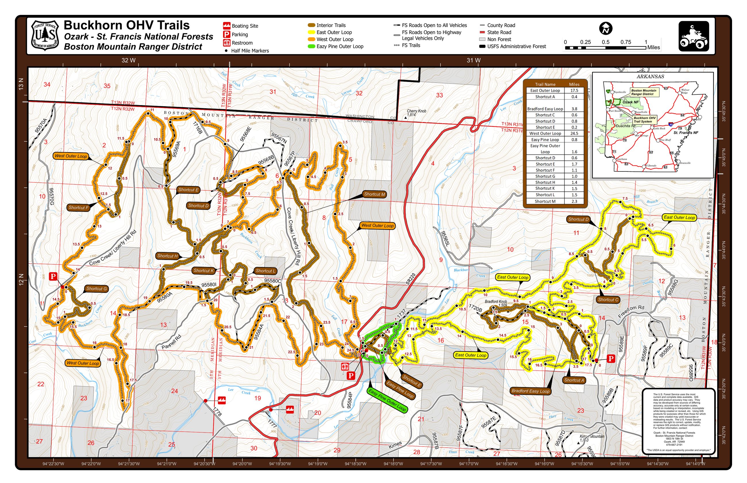
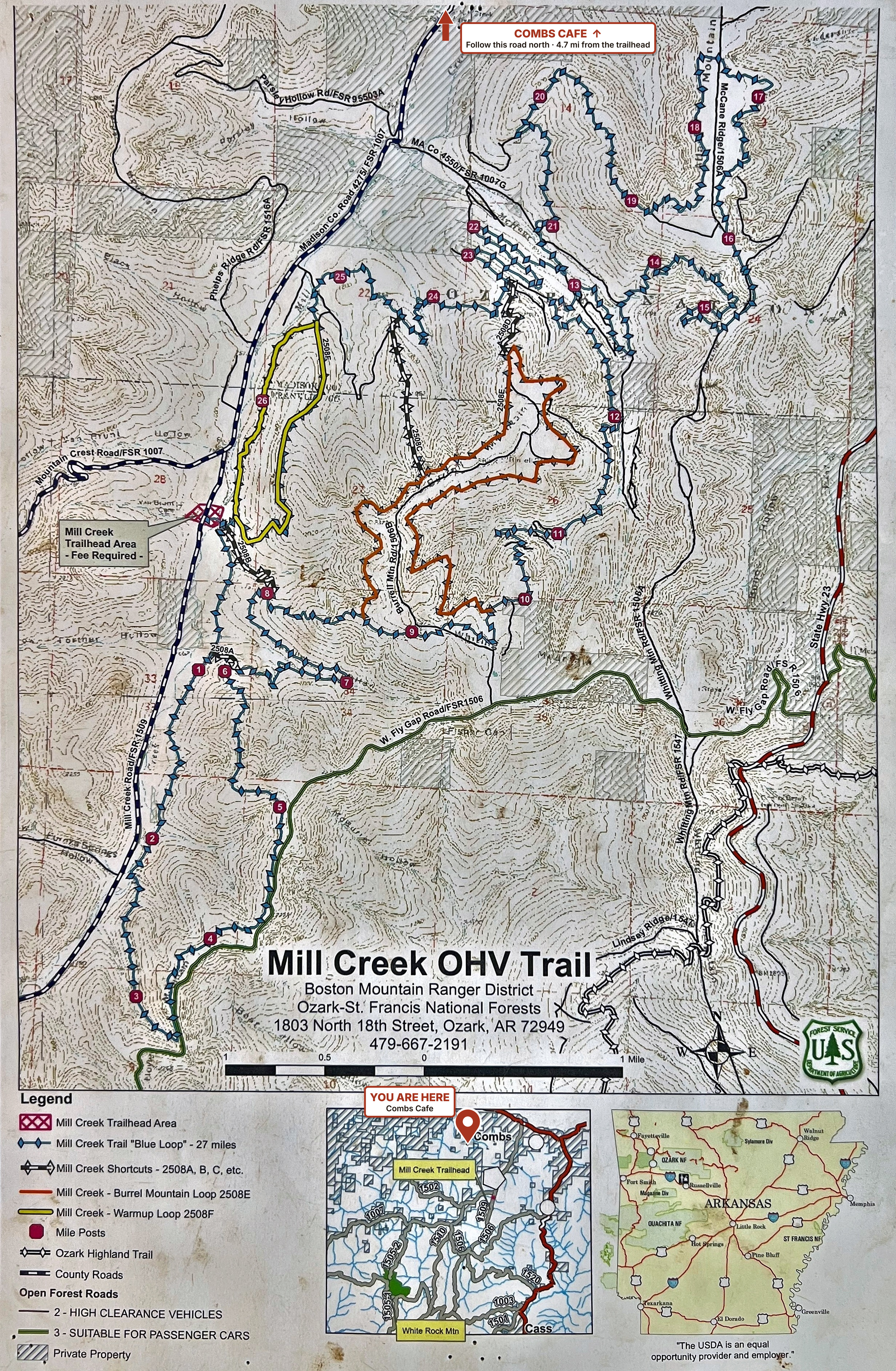
Mill Creek, right by the Cafe, and Buckhorn near Chester. Save the maps before you ride; there's often no signal on the trail.
Tip: save the map to your phone to zoom in on trail numbers and use it with no signal.
Steep climbs, loose rock, creek crossings and waterfalls. The 27-mile Blue Loop is the bucket-list ride; the Warmup Loop is a good shakedown. Difficulty runs moderate to very difficult. The trailhead is on Forest Service Road 1007.
Check with the Forest Service for closures before you ride: Boston Mountain Ranger District, (479) 667-2191
Tip: save the map to your phone to zoom in on trail numbers and use it with no signal.
About 60 miles of Forest Service OHV trail near Chester, about an hour and a half from the Cafe. ATVs and UTVs 72 inches wide or less. Trailhead: 19454 N Lee Creek Rd, Chester.
Check with the Forest Service for closures before you ride: Boston Mountain Ranger District, (479) 667-2191
Tip: save the map to your phone to zoom in on trail numbers and use it with no signal.
Buckhorn OHV Trails, near Chester. Map courtesy of the USDA Forest Service, 2026.
Where to ride, hike and float around Combs, plus a place to park the rig and folks we trust when something breaks.
Forest Service OHV trails close to the Cafe. Trail map
An ATV and UTV park on the Mulberry River with camping and cabins. One of our friends.
Forest Service OHV trails near Chester, 72 inches wide or less. Trail map
A short hike to a wide waterfall near Boston.
A waterfall that pours through a hole in a rock ledge, near Fallsville.
A bluff-top overlook with a rim trail and stone cabins. A favorite for dual-sport and adventure bikes.
One of the most photographed overlooks in Arkansas, near Boxley.
A short trail past waterfalls and a cave, near Ponca.
A state park with trails and a creek, near West Fork.
A long-distance hiking trail through the hills around us.
Canoe and kayak from Ponca, best in spring when the water is up. Park paddling info
Canoe, kayak and raft rentals on the Mulberry River. turnerbend.com
A state park with a pool and creek, near Huntsville.
Highway 23 south from Brashears, a well-known motorcycle ride.
A valley where elk are often seen, near Ponca.
Listed as ideas only. We don't operate these places and can't vouch for conditions, closures, fees or rules. Drive times are rough estimates. Please contact each location before you go.
Cards accepted; cash preferred.
Call to reserveWe're a fuel stop just off Section 2, Deer to Mountainburg. Fill up with 89 non-ethanol, grab a hot meal and stock up before the next leg.
Get the official route & GPS tracksMental Mods is 1 mile north, right here in Combs. SxS, ATV and dirt bike repair, all brands. We vouch for them 100%. mentalmodsar.com
Neighbors we trust for a place to stay, a repair, a ride or a good meal.
UTV rentals, guided tours, cabins and RV sites with ride-in access to the Mill Creek trails.
Cabins, glamping sites and RV hookups in Brashears.
Camping, cabins, ATV and UTV trails, and canoe and kayak rentals on the Mulberry River.
Lodge rooms, cabins, RV and tent camping, and UTV and ATV trails.
SxS, ATV and dirt bike repair right here in Combs, all brands.
A Harley-Davidson dealership in Rogers with sales, service and parts.
Indian, Triumph, BMW and Ducati dealer with service, parts and riding gear. An Ozarks BDR-X dealer.
Independent local businesses and folks. We're not affiliated; they're neighbors we're glad to send you to.
Long before the trails and the Cafe, Combs was a railroad town, a logging hub and, for a while, a gold-mining camp.
From the Archive
The original blueprint plat of our town, surveyed in July & August 1913. Tap the dots to explore what was here then — and where you're standing now.
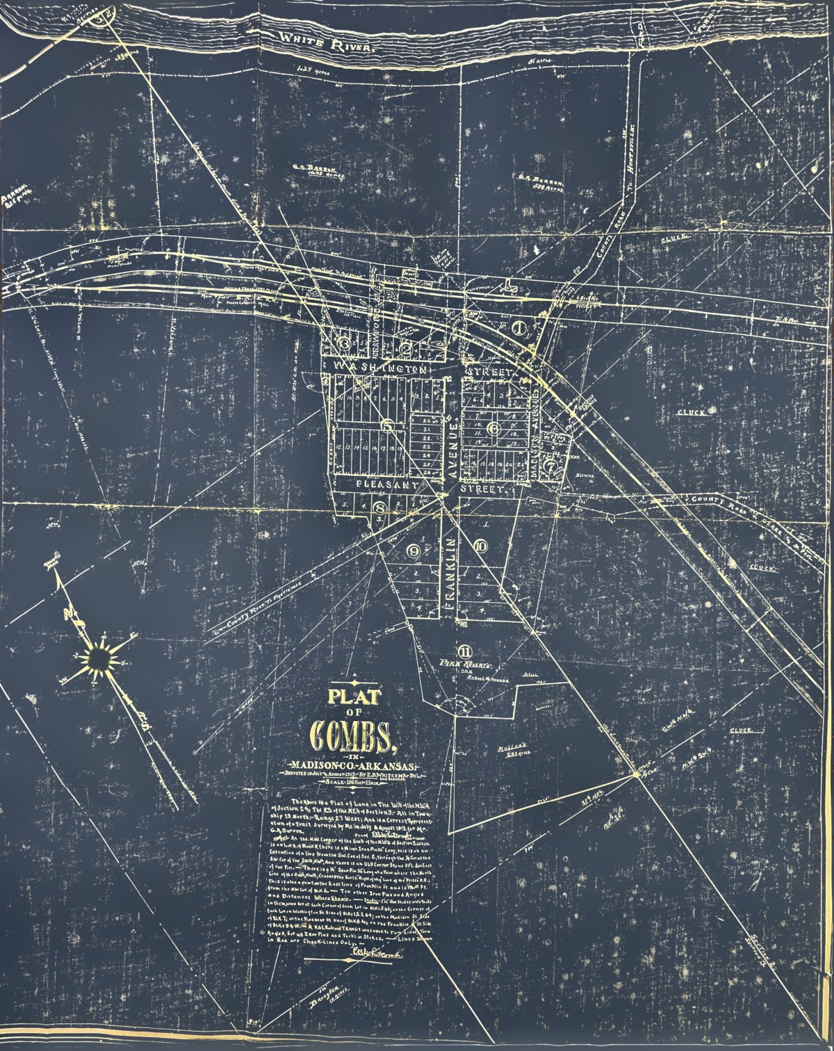
Today's landmarks are placed by lining the plat up with USDA/USGS aerial imagery and are approximate, within about 30–50 meters. Open the full-size plat →
Combs was already a community before the railroad came — a post office opened here in 1888, named for Captain Hiram Hite Combs, one of the first settlers. In July and August of 1913, civil engineer E.B. Whitcomb ran his transit across the river bottom for G.A. Barron and drew the town you see above: eleven numbered blocks on Washington and Pleasant Streets and Crawford, Gussie, Franklin and Madison Avenues, with Block 11 set aside as a Park Reserve and School Grounds.
The Frisco's St. Paul branch ran east–west across the sheet, with a depot and a passing track. The Phipps Lumber Company mill sat on the tracks west of town, and a brand-new logging line — lettered Black Mountain & Eastern — curved off to the southeast toward Mill Creek and Cass. Look closely at that name: the railroad didn't officially adopt it until 1915, so either it was in use early, or someone added it to the plat later.
The timber boom faded after World War I. Once Highway 16 connected through, trucks could do the railroad's job, and in July 1937 the last Frisco train left. The tracks were pulled up, leaving only the roadbed. The highway that ended the railroad is the one that brings you to our door.
Whitcomb hand-lettered his certificate right on the plat, tying the town to iron pins and oak stakes.
Sources: the original 1913 Plat of Combs (privately held); Encyclopedia of Arkansas, "Combs, Cass and Eastern Railroad" and "Pettigrew"; "Combs, Arkansas" (Wikipedia); "J.H. Phipps and the timber industry" (University of Arkansas).
On the 1913 plat
The Above is a Plat of Land in The W½ of the N.W.¼ of Section 2 and The E½ of the N.E.¼ of Section 3. — All in Township 13 North. — Range 27 West; And is a Correct Representation of a Tract Surveyed by Me in July & August 1913, for Mr. G.A. Barron.
Signed, E.B. Whitcomb, Civil Engineer
Pins. At the N.W. Corner of the SW¼ of the NW¼ of Section 2, Which is on Lot 9, of Block 5, there is a ¼ inch Iron Pin 36" Long; this is on an Extention of a line from the SW. Cor. of Sec. 2, through the ¼ Cor. at the SW. Cor. of the SW¼ NW¼, And there is an OLD Corner Stone 3 Ft. due East of the Pin. — There is a ¾" Iron Pin 36" Long at a Point where the North Line of the SW¼ NW¼, Crosses the South "Right of Way" Line of the "Frisco" R.R.; This is also a point on the East line of Franklin St. and is 196.[?] Ft. from the NW. Cor. of BLK 6. — Ten other Iron Pins and Angles and Distances Where Shown.
Stakes. 2"x2" Oak Stakes with Tacks in them, were set at each Corner of each Lot in BLKs 5 & 6; on the Corner of each Lot on Washington St. Side of BLKs 1, 2, 3, & 4; on the Madison St. Side of BLK 7; on the Pleasant St. Side of BLK 8, and on the Franklin St. Side of BLKs 9 & 10. — A K&E Railroad Transit was used to run Lines, Turn Angles, Set all Iron Pins and Tacks in Stakes. — Lines Shown in Red are Check-Lines Only. —
E.B. Whitcomb.
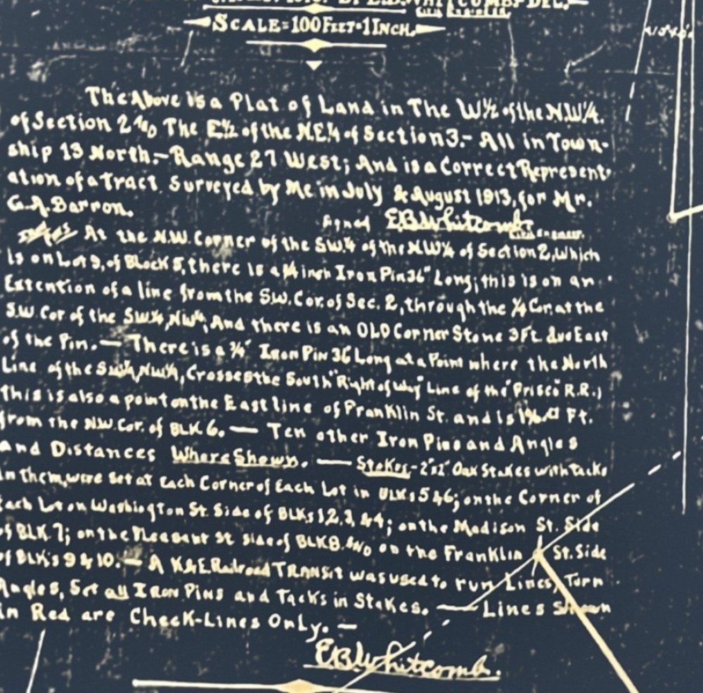
Transcribed word-for-word from the original 1913 Plat of Combs.
Two towns, one family, two generations apart
Elijah Combs was the first settler at Hazard, Kentucky, and helped organize Perry County there. In 1826 he deeded the land where downtown Hazard now stands. He died in 1855 and rests on a small hilltop cemetery above the town he started.
Hiram Combs was born in Perry County, Kentucky, in 1832, the son of Elijah Combs Jr. and his wife Polly. Family records trace that line back to Elijah, Hazard’s founder.
In the spring of 1854 Hiram left Perry County. After a short stay in Kansas he settled in Madison County, Arkansas, that fall and took up farming. His mother Polly later came west as well.
During the Civil War he served as a Confederate officer, rising to captain and fighting at Prairie Grove and Marks’ Mill.
After the war he was elected county coroner, and in 1880 he became sheriff. In 1888 he was appointed postmaster, and the new post office here took his name: Combs.
Captain Hiram Hite Combs died in 1917 and is buried at Brashears Cemetery in Madison County.
We’re still piecing this history together. If you’re kin to the Combs family or remember something different, we’d love to hear from you.
Sources: Kentucky Historical Society: Founder of Hazard · Goodspeed’s biography of Hiram Combs (1889) · Combs Families: Elijah Combs Sr. · Wikipedia: Combs, Arkansas

Combs Train Depot — Frisco Line, circa 1910 · Photo courtesy of Mary Ellen Johnson · Encyclopedia of Arkansas
The railroad reached this valley in 1887, when the line from Fayetteville to St. Paul — soon a branch of the St. Louis–San Francisco Railway (the "Frisco") — came through Combs. In 1913, the Combs, Cass & Eastern Railroad began construction right here, heading south along Mill Creek for nearly nine miles before climbing toward High Cass in Franklin County. It was the last railroad built in northwest Arkansas. The Combs, Cass & Eastern was gone by 1928, and the last Frisco train ran to St. Paul in 1937.
Sources: Encyclopedia of Arkansas: St. Paul (Madison County) · Encyclopedia of Arkansas: Combs, Cass and Eastern Railroad

Carl Wright at the gold mine, Combs · Chloe Thomas Collection · Shiloh Museum of Ozark History
Yes — there was a gold mine at Combs, and the mine shaft is right here on our property. In the early 1900s, a gold mine operated here, adding to the already-bustling railroad economy. The Boston Mountains of Madison County have long held secrets in their hills, and for a brief time, gold was among them.

Logging Railroad Yard — Boston Mountains, early 1900s
Combs sat at the heart of one of the great logging booms in the Ozarks. The Combs, Cass & Eastern Railroad was built in 1913 to haul logs out of the mountains to the J. H. Phipps sawmills at Combs and Fayetteville, crossing four big wooden trestles — the largest 385 feet long and 77 feet high. By 1928 the line was gone. The forests that remain today are the second-growth descendants of those ancient stands.
Sources: Encyclopedia of Arkansas: Combs, Cass and Eastern Railroad · University of Arkansas: J. H. Phipps and the timber industry in Northwest Arkansas
 Since 1951The store on Highway 16
The building that's now Combs Cafe & General Store
The cinder-block store on Highway 16 was built in 1951.
After the Hawkins years, the store passed to the Blevins and Mounce families. Charles and Carolyn Blevins ran it into the late 1980s. Folks around Combs knew it as B&M, and the name stuck.
Gene and Wanda Kimball ran the store for nearly three decades. They kept the B&M name and made it stand for Breakfast and More. Wanda was loved and will always be remembered.
In 2016 Carlos Mayo renamed the store The Combs Store & Cafe and made some upgrades: an addition to the building, air conditioning, a new kitchen hood over the grill, a back deck for live acoustic music, and fried catfish on Friday nights.
Since 2025 it has been Combs Cafe & General Store, still serving folks from the same building on Highway 16.
We’re still piecing this history together and checking the details, so please excuse any mistakes. If you remember something different or have old photos of the store, we’d love to hear from you. Stop in or call (479) 677-2783.
Source: Northwest Arkansas Democrat-Gazette, “Old store in Combs getting a fresh look,” May 22, 2016.
The grill closes 30 minutes before the store.
From Fayetteville, head east on AR-16. From Huntsville, take AR-23 south to Brashears, then AR-16 west into Combs.
Get directions